Sunday, February 03, 2008
Notes on the western drought
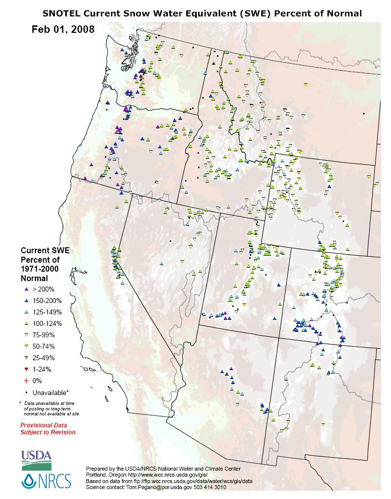
I was on the phone with my sister-in-law (the best vet in Durango, Colorado!) a couple of nights ago, and she reported that she had spent the last six hours clearing several feet of snow from her long driveway. That reminded me that in early January I flew over the West from San Francisco, and was impressed with the brilliance of the snow cover. The Rockies seemed buried in the stuff. My superficial take from 30,000 feet proved to be correct. According to the National Climate Data Center, virtually the entire West is running a large surplus in "snow water equivalent" this winter, meaning that snow on the ground will melt into substantially more water than was usual even during the wet years of 1971-2000. In the graphic below, the upward arrows indicate surplus snow water equivalent.
That got me to wondering, what is up with the Western drought?
The American west has, until recently, been in a prolonged drought. It has raised questions about the ability of the region to absorb its rapidly growing population, at least without profound changes in patterns of water consumption. Explosively growing Las Vegas is apparently the epicenter of the looming water shortage, and it will have a regional impact. What happens in Vegas does not necessarily stay in Vegas.
Of course, the American west is arid and was never capable of absorbing coastal-style population density, but the drought has caused lakes Mead and Powell (and others) to shrink. The receding shorelines of the reservoir lakes have provoked a fair amount of press coverage. The February issue of National Geographic features a very interesting and fairly balanced story on "The Drying of the West."
Not surprisingly, there is a great desire to spin the Western drought as the consequence of anthropogenic global warming. A new study publicized just four days ago argued that -- notwithstanding the massive snowfall this year -- AGW was pushing the West into a period of sustained drought. It is indeed the case that leading climate models and garden-variety geophysics show that AGW will cause dry regions to get drier, and wet regions to get wetter:
The future, though, won't be governed by that kind of natural fluctuation alone. Thanks to our emissions of greenhouse gases, it will be subject as well to a global one-way trend toward higher temperatures. In one talk at Lamont, climate theorist Isaac Held, from NOAA's Geophysical Fluid Dynamics Laboratory in Princeton, gave two reasons why global warming seems almost certain to make the drylands drier. Both have to do with an atmospheric circulation pattern called Hadley cells. At the Equator, warm, moist air rises, cools, sheds its moisture in tropical downpours, then spreads toward both Poles. In the subtropics, at latitudes of about 30 degrees, the dry air descends to the surface, where it sucks up moisture, creating the world's deserts—the Sahara, the deserts of Australia, and the arid lands of the Southwest. Surface winds export the moisture out of the dry subtropics to temperate and tropical latitudes. Global warming will intensify the whole process. The upshot is, the dry regions will get drier, and the wet regions will get wetter. "That's it," said Held. "There's nothing subtle here. Why do we need climate models to tell us that? Well, we really don't."
Notwithstanding Professor Held's certainty, the correlation between global temperatures, at least, and precipitation in the American West does not appear to be linear. The same article describes the 1980s and early 1990s, also periods of warming global temperatures and mild winters in the northern United States, as wetter than usual in the Rockies. Indeed, the 20th century, thought by AGW scientists and activists to be the warmest century in the last couple of dozen, was unusually wet in the American West. Consider the waxing and waning of the Colorado River, by far the most important source of water in the region (bold emphasis added):
The Colorado supplies 30 million people in seven states and Mexico with water. Denver, Las Vegas, Phoenix, Tucson, Los Angeles, and San Diego all depend on it, and starting this year so will Albuquerque. It irrigates four million acres of farmland, much of which would otherwise be desert, but which now produces billions of dollars' worth of crops. Gauges first installed in the 19th century provide a measure of the flow of the river in acre-feet, one acre-foot being a foot of water spread over an acre, or about 326,000 gallons. Today the operation of the pharaonic infrastructure that taps the Colorado—the dams and reservoirs and pipelines and aqueducts—is based entirely on data from those gauges. In 2002 water managers all along the river began to wonder whether that century of data gave them a full appreciation of the river's eccentricities. With the lawns dying in Denver, a water manager there asked Woodhouse: How often has it been this dry?
Over the next few years Woodhouse, Meko, and some colleagues hunted down and cored the oldest drought-sensitive trees they could find growing in the upper Colorado basin, both living and dead. Wood takes a long time to rot in a dry climate; in Harmon Canyon in eastern Utah, Meko found one Douglas fir log that had laid down its first ring as a sapling in 323 B.C. That was an extreme case, but the scientists still collected enough old wood to push their estimates of annual variations in the flow of the Colorado back deep into the Middle Ages. The results came out last spring. They showed that the Colorado has not always been as generous as it was throughout the 20th century.
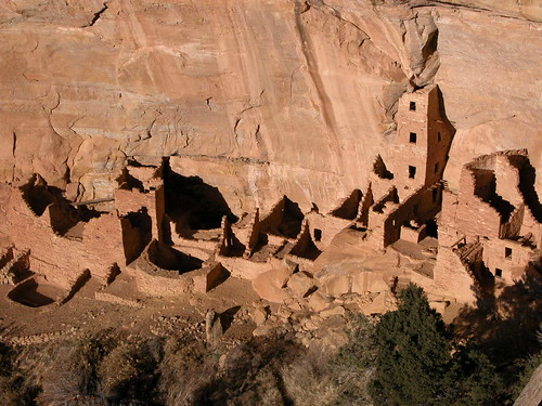
The California Department of Water Resources, which had funded some of the research, published the results as an illustrated poster. Beneath a series of stock southwestern postcard shots, the spiky trace of tree-ring data oscillates nervously across the page, from A.D. 762 on the left to 2005 on the right. One photo shows the Hoover Dam, water gushing from its outlets. When the dam was being planned in the 1920s to deliver river water to the farms of the Imperial Valley and the nascent sprawl of Los Angeles, the West, according to the tree rings, was in one of the wettest quarter centuries of the past millennium. Another photo shows the booming skyline of San Diego, which doubled its population between 1970 and 2000—again, an exceptionally wet period along the river. But toward the far left of the poster, there is a picture of Spruce Tree House, one of the spectacular cliff dwellings at Mesa Verde National Park in southwestern Colorado, a pueblo site abandoned by the Anasazi at the end of the 13th century. Underneath the photo, the graph reveals that the Anasazi disappeared in a time of exceptional drought and low flow in the river.
In fact, the tree rings testified that in the centuries before Europeans settled the Southwest, the Colorado basin repeatedly experienced droughts more severe and protracted than any since then. During one 13-year megadrought in the 12th century, the flow in the river averaged around 12 million acre-feet, 80 percent of the average flow during the 20th century and considerably less than is taken out of it for human use today. Such a flow today would mean serious shortages, and serious water wars. "The Colorado River at 12 million acre-feet would be real ugly," says one water manager.
See more on pre-historic North American droughts here. There is no discussion whether such droughts coincided with pre-industrialization warming periods, so we do not know whether Isaac Held's claim that there is "nothing subtle" about the correlation between higher global temperatures and lower precipitation in arid regions is generally correct. We do know, however, that Held's correlation must nevertheless be sufficiently "subtle" to accomodate two inconvenient facts -- that the 20th century saw the highest global temperatures in history and unusually large precipitation in the American West. May I respectfully suggest that the influence of AGW on rain and snow in the Colorado river watershed remains largely in the minds of people who wish it were so?
You do not like my simple objection to the AGW-Western drought connection? Here is a rather more data-driven blog post that does far more damage to the AGW-Western drought link than I ever could.
Of course, the intellectual dishonesty of the climate activists should not comfort pro-growth Westerners. AGW aside, the West was settled during an unusually wet period. If the arid Western climate reverts to the mean, as it were, population growth will have to slow down and habits in the use of water, now profligate, will have to change.
10 Comments:
By  jon spencer, at
Sun Feb 03, 03:41:00 PM:
jon spencer, at
Sun Feb 03, 03:41:00 PM:
How much treated waste water is dumped into the
Pacific ocean every day from each city in California? This treated water it is better than what is coming into the potable water treatment plants.
At the very least it could be used for anything that does not require potable water.
By  , at
Sun Feb 03, 05:04:00 PM:
, at
Sun Feb 03, 05:04:00 PM:
I would also suggest looking at the levels of the Ogallala Aquifer, which has been tapped to irrigate land throughout the prairies of American.
Aridity appears more extreme in the Southwest, but Kansas, Nebraska, Iowa, Oklahoma, eastern Colorada, etc. are the bread basket of this country. These regions also could "dry out".
The relationship between ocean currents and weather may be more profound than simply "global warming". We simply do not clearly understand all the factors that affect warm and cold currents in the oceans, and why they sometimes appear to change in an arbitrary manner.
Jon makes a very good point. The treated "waste water" from the Los Angeles basin cities should be pumped back up hill to fill lakes and reservoirs in California. There are a couple of projects working toward this already, but this could forestall the overuse of other resources, such as Lake Mead and Powell.
-David
By , at
Sun Feb 03, 05:09:00 PM:
"The Rockies seemed buried in the stuff."
I presume you meant the Sierras.
And you're correct. Having grown up skiing every winter in the Sierras for 20-odd years, they're packed as far as the eye can see in deep, clean, fresh-from-the-heavens, almost-ready-for-drinking, pure, unadulterated snow.
It is, as I type, a delightful 26 degrees ("feels like 16") in Truckee, CA, heart of the snow country. I presume, because of the wanton use of SUVs 800 years ago, that if the earth warms a few degrees over the next century, that "26" + "a few degrees" doesn't mean the entire snowpack will melt. Are we in agreement on that?
"If the arid Western climate reverts to the mean, as it were, population growth will have to slow down and habits in the use of water, now profligate, will have to change."
So, if there's more water sitting there than the imagination of man can account for, why does anything have to "slow down"?
It is really a water issue?
Or is it an availability issue?
By Miss Ladybug, at
Sun Feb 03, 08:33:00 PM:
It's things like this that kinda tick me off about "climate experts". They make pronouncements stating "it IS this way" instead of stating it as a THEORY. We don't know what we don't know about everything that affects climate. When they declare something an absolute certainty (kinda like the "global cooling" scare of the 70s) when they KNOW they don't have all the facts is scientific dishonesty...
By , at
Sun Feb 03, 08:40:00 PM:
1300 AD? Isn't that about the time the Vikings found their potato farms in Greenland being turned into Ice Farms?
I agree with your previous commenters (and you) :) Weather is unbelievably complex. As for CO2? It was about six times as high during the Carbonaceous period as it is now; and, they promptly went into an Ice Age that lasted for like a zillion years, or something.
By , at
Mon Feb 04, 12:06:00 AM:
I live in Vegas, despite the nickname. Our 3 bedroom house generates about eight dollars in water bills every month. How this is possible is beyond me.
By , at
Mon Feb 04, 12:45:00 AM:
So much for all that global warming this just proves that AL GORE and GREEPEACE are full of bull poo and so is ENVIROMENTAL DEFENSE FUND their all crazy bunch of liars
By joated, at
Mon Feb 04, 12:07:00 PM:
Keep an eye on the golf tournament coverage in the coming weeks. I cringe everytime they go to a blimp shot of the course and the surrounding area. All you see is the (normal) dry desert plants and grasses surrounding the lush green of the watered lawns and fairways. And every home has a swimming pool. And then the residents wonder why they are short on drinking water.
By Who Struck John, at
Mon Feb 04, 08:11:00 PM:
Those sno-tel maps are showing water water everywhere in the Cascades because we've had some unusual weather in the Pacific Northwest the last two weeks - there's been a low in the Gulf of Alaska that spits a new front at us every two days, and the snow level keeps hovering in the 1,000 to 2,000 ft. level. So we have a lot of snow at lower elevations that we normally wouldn't have.
This too shall pass.
By Jim in Virginia, at
Mon Feb 04, 08:38:00 PM:
Twenty years ago a water expert in San Antonio noted the good news and bad news.
"In 30 years we'll be drinking recycled sewage. There won't be enough."
Injection wells in Orange County California pump treated sewage back into the aquifer below the Santa Ana River. The Las Vegas sewage plant feeds Lake Las Vegas. The Occoquan Reservoir, water supply for half of the Northern Virginia DC suburbs, is primarily fed by the Upper Occoquan sewage plant.
Water is like petroleum. If the price gets high enough we'll both conserve, and find new sources: desalinazation, icebergs or pipelines from Canada.
![]()